
Lac de Souliers, par le Col du Tronchet
Sport, Pedestrian sports, Hiking itinerary
in Château-Ville-Vieille
9.0
km
4h 30min
Hard
-
A nice easy hike for good walkers, you reach the high-altitude lake and here you are at the foot of Rochebrune!
-
The trailhead is at the Chapelle in the hamlet of Souliers, aptly named after the word for "sun".
Head up the Souliers valley towards the Bergerie, which is a great place to bivouac, or if you'd like to spend the night in the sheepfold, don't hesitate to contact the "Les Oules" bed and breakfast.
On this path, which runs alongside the torrent, you may be lucky enough to come across François' cows. At the fork in the road, turn left towards the Col du Tronchet.
After a short, winding...The trailhead is at the Chapelle in the hamlet of Souliers, aptly named after the word for "sun".
Head up the Souliers valley towards the Bergerie, which is a great place to bivouac, or if you'd like to spend the night in the sheepfold, don't hesitate to contact the "Les Oules" bed and breakfast.
On this path, which runs alongside the torrent, you may be lucky enough to come across François' cows. At the fork in the road, turn left towards the Col du Tronchet.
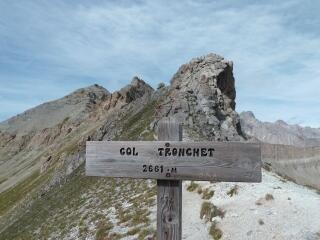
After a short, winding climb, you'll reach the Col du Tronchet, where you switch to a mountainside path that leads to a junction where you turn right to reach Lac Souliers (yellow markings), leaving the descent to Brunissard on your left.
Once you've reached Souliers lake, take out your picnic, admire the Rochebrune and, if you fancy a little treat, continue your climb to the Pic Ouest de Côte Belle, and here you are at an altitude of 2854m.
After a break at the lake, you can descend through the Chalanches valley - but watch your legs, as the descent is a little steep at first!
Back at the sheepfold, take the same route back to the hamlet of Souliers.
In spring and autumn, conditions can change, and even snow-free trails can be icy. As a result, the reflex in the mountains is to "go out well equipped". In my bag, I slip or I hang: crampons and poles.
In winter, the right reflexes are: snowshoes, poles, gloves, hat, sun cream and... a survival blanket! Experience is essential, and knowing when to give up is sometimes preferable to taking risks. And if you're new to the mountains, don't hesitate to call in a professional! Before going out, I check the Météo France Montagnes and BERA bulletins (risks and avalanches).
- Departure
- Château-Ville-Vieille
-
-
Difference in height
- 632.969 m
-
-
-
Plain text period
-
All year round daily.
Subject to favorable snow and weather conditions.
-
-
-
Spoken languages
-
-
-
-
-
Documentation
-
- Lac de Souliers, par le Col du Tronchet_Château-Ville-Vieille
- Lac de Souliers, par le Col du Tronchet
-
- 633 meters of difference in height
-
- Maximum altitude : 2480 m
- Minimum altitude : 1827 m
- Total positive elevation : 633 m
- Total negative elevation : -633 m
- Max positive elevation : 569 m
Services
-
-
Services
-


